CBEngine is a microscopic traffic simulation engine that can support city-scale road network traffic simulation. CBEngine can support fast simulation of road network traffic with thousands of intersections and hundreds of thousands of vehicles. CBEngine is developed by the team from Yunqi Academy of Engineering. This team will provide timely support for this competition.
The road network file contains the following three datasets.
Intersection dataset
Intersection data consists of identification, location and traffic signal installation information about each intersection. A snippet of intersection dataset is shown below.
The attributes of intersection dataset are described in details as below.
Attribute Name
Example
Description
latitude
30.279547600
local latitude
longitude
120.1653304000
local longitude
inter_id
25926073
intersection ID
signalized
1
1 if traffic signal is installed, 0 otherwise
Road dataset
Road dataset consists information about road segments in the network. In general, there are two directions on each road segment (i.e., dir1 and dir2). A snippet of road dataset is shown as follows.
The attributes of road dataset are described in details as below.
Direction 1 is <from_inter_id,to_inter_id>. Direction 2 is <to_inter_id,from_inter_id>.
Attribute Name
Example
Description
from_inter_id
28571560
upstream intersection ID w.r.t. dir1
to_inter_id
4353988632
downstream intersection ID w.r.t. dir1
length (m)
93.2000000000
length of road segment
speed_limit (m/s)
20
speed limit of road segment
dir1_num_lane
3
number of lanes of direction 1
dir2_num_lane
3
number of lanes of direction 2
dir1_id
1
road segment (edge) ID of direction 1
dir2_id
2
road segment (edge) ID of direction 2
dir1_mov
1 0 0 0 1 0 0 1 1
every 3 digits form a permissible movement indicator for a lane of direction 1, 100 indicates a left-turn only inner lane, 010 indicates through only middle lane, 011 indicates a shared through and right-turn outer lane.
dir2_mov
1 0 0 0 1 0 0 1 1
every 3 digits form a lane permissible movement indicator for a lane of direction 2.
Traffic signal dataset
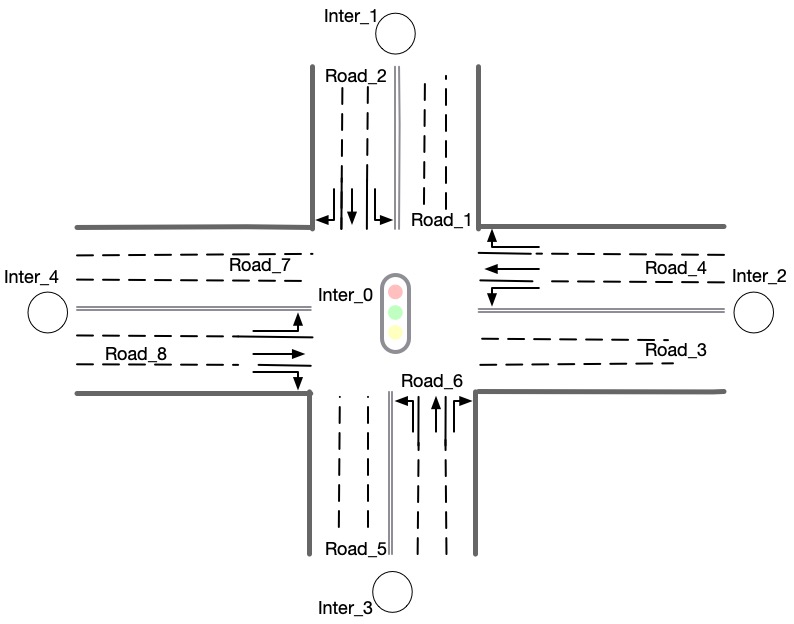
This dataset describes the connectivity between intersection and road segments. Note that, we assume that each intersection has no more than four approaches. The exiting approaches 1 to 4 starting from the northern one and rotating in clockwise direction. Here, -1 indicates that the corresponding approach is missing, which generally indicates a three-leg intersection.
Flow file is composed by flows. Each flow is represented as a tuple (start_time, end_time, vehicle_interval, route), which means from start_time to end_time, there will be a vehicle with route every vehicle_interval seconds. The format of flows contains serval parts:
The first row of flow file is n, which means the number of flow.
The following 3n rows indicating configuration of each flow. Each flow have 3 configuration lines.
The first row consists of start_time, end_time, vehicle_interval.
The second row is the number of road segments of route for this flow : k.
The third row describes the route of this flow. Here flow’s route is defined by roads not intersections.
12// n = 1201005// start_time, end_time, vehicle_interval2// number of road segments23// road segment IDs0100522501005227010052450100524701005241010052670100526101005263010052810100528301005285
Participants will be able to get a full observation of the traffic on the road network at every 10 seconds, including vehicle-level information (e.g., position, speed) and lane-level information (e.g., average speed of each lane, number of vehicles on each lane). These observations will be helpful for decision-making on the traffic signal phase selection. Detailed description the features of observation can be found in agent/gym_cfg.py.
The format of observations could be found at annotation in code blocks in observation format.
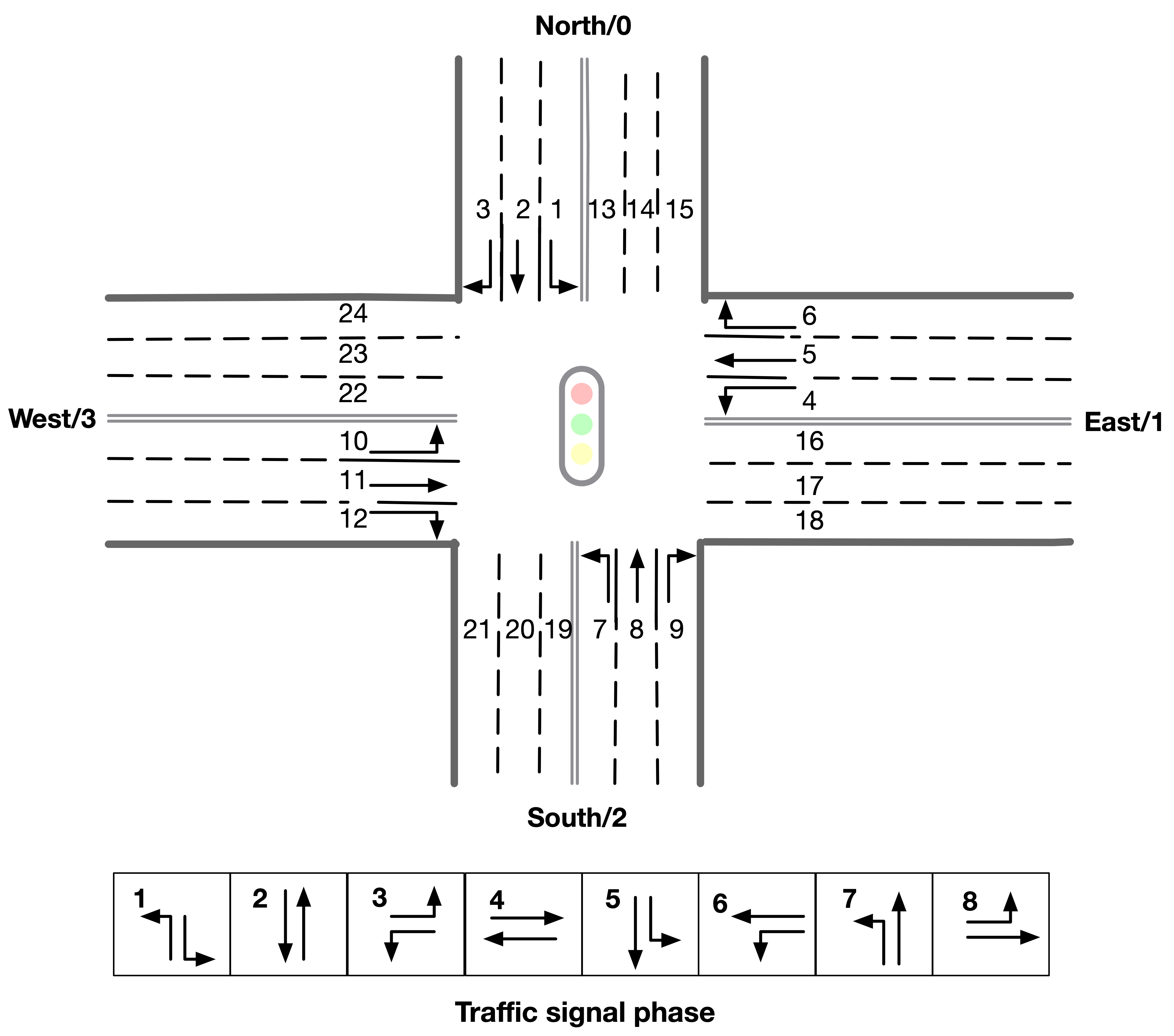
For a traffic signal, there are at most 8 phases (1 - 8). Each phase allows a pair of non-conflict traffic movement to pass this intersection. Here are illustrations of the traffic movements and signal phase.
For example, if an agent is at phase 1, lane_1 and lane_7 along with all right turning lanes are passable. The index of the lanes in observation and reward could be found in observation format.
There are a total of 8 different types of phases for a standard four-way intersection. You can also learn how to set the traffic signals with the information given on the APIs page.
The action is defined as the traffic signal phase for each intersection to be selected at next 10 seconds. If an agent is switched to a different phase, there will be a 5 seconds period of ‘all red’ at the beginning of the next phase, which means all vehicles could not pass this intersection. We fix env.step() as 10 seconds for practical implementation consideration, which means the decision can be made every 10 seconds.